Pittsburgh 2
I had a lazy morning while I waited for the rain to let up. I used the time well to do some trip planning. You would think that by now I would know to check in advance if timed tickets are required. Yet I got caught flat-footed again. Fortunately one of my destinations in Philly releases additional tickets the night before, so hopefully I can snag one of those.
Once the rain stopped, I walked over to the Fort Pitt Museum . This museum provides the entire history of Pittsburgh , which was instrumental in a number of wars, including the French and Indian War, the Seven Years War (a global confrontation between Britain and France fought in both hemispheres), and Revolutionary War. The history of this region is so convoluted, involving multiple interactions between the Indigenous peoples, the British colonials and the French colonials, that it will be impossible to truly do it justice in this forum. For those interested, I commend you to the links in the following paragraphs.
Algonquian- and Iroquoian-speaking peoples were early inhabitants of the region. With the advent of colonization, forts at the site of present-day Pittsburgh changed hands between the British and the French with dizzying speed. Fort Prince George was only half-built in 1754, when French forces arrived with superior numbers and ordered the colonials back to Virginia. The French tore down the British fortification and constructed Fort Duquesne. In 1758, after other losses in area, the French abandoned and razed Fort Duquesne. John Forbes occupied the burned fort, and ordered the construction of Fort Pitt, named after British Secretary of State William Pitt the Elder. He also named the settlement between the rivers "Pittsborough.” Settlers began arriving after Native American forces led by Ottawa chief Pontiac were defeated in 1763; an agreement subsequently was brokered between Native American groups and the Penn family, and a boundary dispute was ended between Pennsylvania and Virginia. That resulted in establishment of the Mason-Dixon Line . Interestingly, many references to Duquesne remain in the City.
As happened ubiquitously in Colonial America, and continued even once the Union was formed, treaties with various tribes and coalitions of Native Americans were consummated, and then summarily broken. Fort Pitt was the site of many of these transactions.
Following the American Revolution, the Pittsburgh became an hub to outfit settlers traveling westward down the Ohio River. In 1811, the first steamboat was built in Pittsburgh, enabling commerce to also flow upriver. The War of 1812 with Britain catalyzed further growth of the Iron City as the supply of British goods was disrupted, stimulating American manufacture. In addition, the British blockade of the American coast increased inland trade, so that goods flowed through Pittsburgh from all four directions. As has happened throughout history, war ironically stimulated the economy. When, in 1816, Pittsburgh was incorporated as a city, it had already acquired some of its defining characteristics: commerce, manufacture, and a constant cloud of coal dust. Moving forward, the history of iron and steel production was discussed in yesterday’s post.
Additional information about the history of Pittsburgh can be found here , here , here and here.
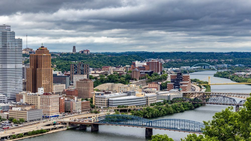
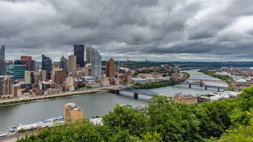
After my visit to the Fort Pitt Museum, I finally had a chance to take the historical inclines up and down Mount Washington. The Duquesne Incline opened 1877, was rescued and restored by a group of local residents in 1963, and still maintains its original, elegant, wooden cable cars. I won’t lie, this trip was a little scary as it is quite steep and the age of the machinery is evident. I then walked along the appropriately-named Grandview Avenue to view additional cityscapes of downtown Pittsburgh, the river, and the bridges. After less than a mile I arrived a the Monongahela Incline, which I intend to take down the mountain.
The recently refurbished Monongahela Incline was built in 1870 to transport workers up and down "Coal Hill" which was otherwise almost inaccessible from the city proper. "Coal Hill" is now known as Mount Washington. You can see the remnants of a much larger freight incline that ran parallel to the passenger incline until about 1935. The larger incline was capable of transporting horse-drawn freight, and later, motor vehicles. Though only two inclines survive, Pittsburgh was once home to almost two dozen inclines, which provided Pittsburgh residents and their vehicles access to neighborhoods above the steep hills that surround the city. For some reason this incline was less scary. The trip was shorter and the machinery felt more stable.
Tomorrow I head East again to Lancaster, where I will be meeting a friend who I know from one of my trips to the Katmai Peninsula in AK. T was on staff at the lodge that summer and is currently living in PA. So it will be fun to meet.
Once the rain stopped, I walked over to the Fort Pitt Museum . This museum provides the entire history of Pittsburgh , which was instrumental in a number of wars, including the French and Indian War, the Seven Years War (a global confrontation between Britain and France fought in both hemispheres), and Revolutionary War. The history of this region is so convoluted, involving multiple interactions between the Indigenous peoples, the British colonials and the French colonials, that it will be impossible to truly do it justice in this forum. For those interested, I commend you to the links in the following paragraphs.
Algonquian- and Iroquoian-speaking peoples were early inhabitants of the region. With the advent of colonization, forts at the site of present-day Pittsburgh changed hands between the British and the French with dizzying speed. Fort Prince George was only half-built in 1754, when French forces arrived with superior numbers and ordered the colonials back to Virginia. The French tore down the British fortification and constructed Fort Duquesne. In 1758, after other losses in area, the French abandoned and razed Fort Duquesne. John Forbes occupied the burned fort, and ordered the construction of Fort Pitt, named after British Secretary of State William Pitt the Elder. He also named the settlement between the rivers "Pittsborough.” Settlers began arriving after Native American forces led by Ottawa chief Pontiac were defeated in 1763; an agreement subsequently was brokered between Native American groups and the Penn family, and a boundary dispute was ended between Pennsylvania and Virginia. That resulted in establishment of the Mason-Dixon Line . Interestingly, many references to Duquesne remain in the City.
As happened ubiquitously in Colonial America, and continued even once the Union was formed, treaties with various tribes and coalitions of Native Americans were consummated, and then summarily broken. Fort Pitt was the site of many of these transactions.
Following the American Revolution, the Pittsburgh became an hub to outfit settlers traveling westward down the Ohio River. In 1811, the first steamboat was built in Pittsburgh, enabling commerce to also flow upriver. The War of 1812 with Britain catalyzed further growth of the Iron City as the supply of British goods was disrupted, stimulating American manufacture. In addition, the British blockade of the American coast increased inland trade, so that goods flowed through Pittsburgh from all four directions. As has happened throughout history, war ironically stimulated the economy. When, in 1816, Pittsburgh was incorporated as a city, it had already acquired some of its defining characteristics: commerce, manufacture, and a constant cloud of coal dust. Moving forward, the history of iron and steel production was discussed in yesterday’s post.
Additional information about the history of Pittsburgh can be found here , here , here and here.
After my visit to the Fort Pitt Museum, I finally had a chance to take the historical inclines up and down Mount Washington. The Duquesne Incline opened 1877, was rescued and restored by a group of local residents in 1963, and still maintains its original, elegant, wooden cable cars. I won’t lie, this trip was a little scary as it is quite steep and the age of the machinery is evident. I then walked along the appropriately-named Grandview Avenue to view additional cityscapes of downtown Pittsburgh, the river, and the bridges. After less than a mile I arrived a the Monongahela Incline, which I intend to take down the mountain.
The recently refurbished Monongahela Incline was built in 1870 to transport workers up and down "Coal Hill" which was otherwise almost inaccessible from the city proper. "Coal Hill" is now known as Mount Washington. You can see the remnants of a much larger freight incline that ran parallel to the passenger incline until about 1935. The larger incline was capable of transporting horse-drawn freight, and later, motor vehicles. Though only two inclines survive, Pittsburgh was once home to almost two dozen inclines, which provided Pittsburgh residents and their vehicles access to neighborhoods above the steep hills that surround the city. For some reason this incline was less scary. The trip was shorter and the machinery felt more stable.
Tomorrow I head East again to Lancaster, where I will be meeting a friend who I know from one of my trips to the Katmai Peninsula in AK. T was on staff at the lodge that summer and is currently living in PA. So it will be fun to meet.
61 photo galleries
50 States
- Big Sur
- Salinas
- Laguna Beach
- San Diego
- California
- Grand Canyon
- Sedona
- Utah
- Syracuse
- Moab
- Denver
- Manitou Springs
- Calhan
- Mesa Verde
- Los Alamos
- Santa Fe
- Carlsbad
- New Mexico
- Eureka Springs
- Little Rock
- Birmingham
- Jackson
- Lottie
- Ten Thousand Islands
- Jerome
- Savannah
- White
- Asheville
- Sandstone Falls
- Baltimore
- Timonium
- Maryland
- Berlin
- Milton
- Smyrna
- Ocean City
- Detroit
- Upper Peninsula of Michigan
- Michigan
- Herod
- Ozark
- Two Harbors
- Carlton
- Madison County
- Oakley
- Valentine
- South Dakota
- United States
- Yellowstone National Park
- Lima
- Idaho
- Port Townsend
- Lincoln City
- Newport
- San Francisco